
Touring Destinations – Falls Creek
Falls Creek is situated on the edge of the Bogong High Plains next to the Rocky Valley Dam, and can be reached from Mt Beauty during the winter. There is a large network of groomed XC trails at Falls Creek, and the variety of terrain and numerous huts on the Bogong High Plains make this an interesting place to ski.
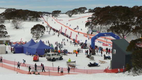
The groomed XC trails are close to the resort, but to reach most of the mountain huts out on the High Plains usually involves a long return ski tour. The 42km Kangaroo Hoppet ski race held in late August is the largest in Australia, and as XC trails are groomed over the surrounding plains and hills to support this race, this is a good time to visit.
Falls Creek Nordic Trails
The Windy Corner Nordic Shelter is situated at the top of Falls Creek resort where the road ends. From here it is a one kilometre ski to the Nordic Bowl, which is often used for lessons and for the start-finish of the Kangaroo Hoppet ski race.
From the Nordic Bowl the groomed XC ski trails fan out into Sun Valley, up the Mt McKay Road, though the trees and slopes above the Nordic Bowl, and around the edge of Rocky Valley Dam. The trails are often groomed all the way to Mt McKay, and down into Pretty Valley to the west of Falls Creek.
During Hoppet week the trails are groomed further out onto the Bogong High Plains, allowing many skaters wearing lycra to practice for the long distance race. The Hoppet race usually goes around Sun Valley then around the edge of the Rocky Valley dam to Watchbed Creek, up the Paralyser to The Park, and along Heathy Spur back to the Nordic Bowl, followed by a shorter second lap around Sun Valley and back towards Watchbed Creek again.
Mt McKay Area
From the Nordic Bowl, there is a gradual climb up the Mt McKay Road to the plateau overlooking the downhill ski runs and the village below. Once onto the plateau, a pole line can be followed north along Frying Pan Spur, which provides great views of Spion Kopje, Mt Bogong and the Kiewa Valley to the north.
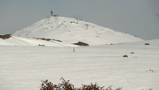
Or one can follow pole lines west across the plateau past Ruined Castle to the base of Mt McKay, then ski up a road to the summit. The views from the summit shelter on Mt McKay are extensive, and include most of the Bogong High Plains, Mt Feathertop, Mt Fainter and Mt Bogong.
Bogong High Plains – East & South of Falls Creek
From the Nordic Bowl, ski over the dam wall then climb up onto Heathy Spur, or ski along the road around the edge of the lake to Watchbed Creek.
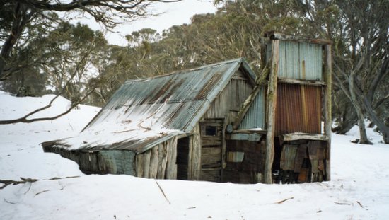
At Watchbed Creek a pole line continues south towards Langford Gap then further on to Wallaces Hut, Cope Hut and the Rover Chalet. An aqueduct track in this area contours around the southern edge of the Bogong High Plains and is usually more sheltered and holds more snow than following the pole line along the Bogong High Plains road.
At Watchbed Creek another pole line climbs east up a long hill known as The Paralyser onto a large open area called The Park. From The Park, Fitzgeralds and Kellys Huts are to the southeast, and Johnstons and Edmondsons Huts are to the north just below Mt Nelse.
A pole line climbs up the slopes of Mt Nelse and continues north past Mt Nelse North to Spion Kopje, the large spur prominent from Falls Creek Village. Further to the north are Ropers Hut and the descent to the Big River and the southern approaches to Mt Bogong. The Main Range in NSW is visible from a few vantage points in this area.
Bogong High Plains – West of Falls Creek
Just to the south of Mt McKay there is a long gradual descent along a road into Pretty Valley and the western section of the Bogong High Plains. The road is usually groomed to just beyond Pretty Valley Hut.
After passing Pretty Valley Hut, pole lines continue south across the plains to Cope Saddle Hut and the Ryders Huts, or west to Pretty Valley Dam.
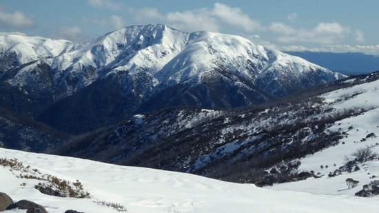
After crossing the causeway at Pretty Valley Dam the pole line climbs west up to the top of a ridge which provides great views of Mt Feathertop and Mt Hotham to the west, and Mt Fainter to the north. Below this ridge further to the west, Tawonga Huts are located amongst trees in a small valley. From Tawonga Huts one can then climb up onto The Niggerheads then continue on to Mt Fainter.
Other destinations at the western edge of the Bogong High Plains include Westons Hut, Mt Jim and Youngs Hut. A pole line along the Alpine Walking Track also continues to Mt Hotham.